|
Overview Asia
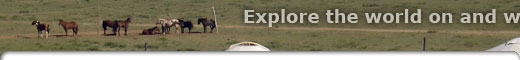
Horseback riding tours
Georgia
India
Mongolia
Sri Lanka
|

|
|
|
|
|
|
Horseback riding vacations in
Mongolia
 Mongolia is a vast country spanning the steppe and deserts of Northeast Asia. Having maintained much of its centuries-old nomadic traditions, Mongolia is one of the only places on earth you can interact with true nomadic peoples, whilst riding traditional Mongolian horses. Mongolia is a vast country spanning the steppe and deserts of Northeast Asia. Having maintained much of its centuries-old nomadic traditions, Mongolia is one of the only places on earth you can interact with true nomadic peoples, whilst riding traditional Mongolian horses.
Hidden Trails have a range of authentic Mongolian horse riding holidays for you to experience – from the lands of Genghis Khan to the untouched Gobi Steppe and Khan Khenti Protected Area.
Horse Riding in Mongolia
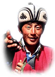
Mongolia is a land still wrapped up in tradition and a nomadic lifestyle. Although low on distinctive, historical "sights," it is of significant interest to those seeking a unique culture, rough scenery and wildlife. Our Hidden Trails horse treks take you through the country, where you’ll find camping in the traditional gers are a perfect way of discovering the traditional Mongol way of life.
Mongolia has a unique and durable traditional culture, centered on the herding lifestyle. Herders remain semi-nomadic, moving their animals with the seasons as they have for centuries. Half of Mongolia's population is rural, and tending to livestock remains the backbone of the Mongolian economy. Join us on an epic horseback vacation adventure on the tracks of Genghis Khan.
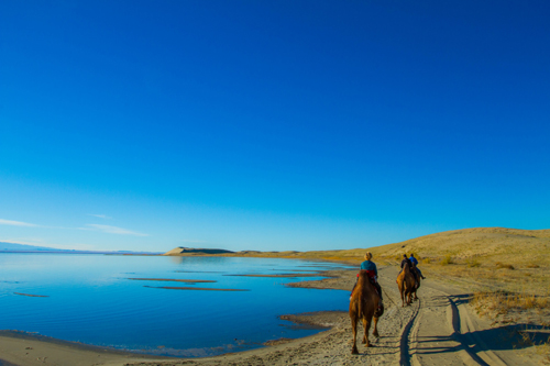
The Gobi Steppe is the only remaining untouched steppe in the world, still wild and unyielding and home to traditional nomadic herders. On our Gobi Steppe Ride, you can live like a Mongolian herder, and experience the “Land of the Blue Sky”.
In the Khan Kentii Protected Area follow the trails of nomadic horsemen, whilst riding hardy Mongolian horses. Our Mongol Horse Trails and Big Sky Trail give you an insight into this unique and vital way of life.
Mongolia Weather and Climate
For most of the year it is very cold, especially at night. Precipitation is low and skies are usually clear during the wintertime. Summers, however, are very pleasant just as in the US and Europe. There is a short rainy season in July and August during which most of the yearly rain falls.
Explore more Asian Horse Riding Vacations
|
|
Holidays on horseback in Mongolia
See Mini Country Guide
|
Below is a list of our trips in this area with video clips.
 Click on the 'watch video' icon

to view a video clip,
Mongolia
Travel restrictions
Mongolia has officially lifted the restriction on inbound/outbound travel starting from June 1st 2021.
As of January 13th 2022, Mongolian authorities have eliminated quarantine requirements for international arrivals, although regulations remain in flux and could change with little notice.
Passengers are required to fill out a medical declaration form upon arrival at the border checkpoints.
Measures taken by government
The SEC mandates the use of protective face masks throughout Mongolia on a situational basis.
Testing
Travelers can obtain a drive-through COVID-19 test at Intermed Hospital. The cost is 33,000MNT. You should first visit the hospital’s website to review COVID-19 test instructions and then make an appointment online. The test result will be delivered via SMS or email within 24 hours. The Mongolian Ministry of Health has also released an online system for those seeking voluntary on-demand testing; however, the website is not currently available in English.
The Mongolian government requires mandatory COVID-19 testing by the National Center for Communicable Diseases (NCCD) for all arriving travelers. This testing is free for every traveler to Mongolia from overseas and the testing cost is covered by the Mongolian government.
Emergency number (related to COVID-19) while visiting the country
Mongolia started working a COVID-19 information call center at “119”. However, calls are made only in Mongolian.
Source:
US Embassy in Mongolia https://mn.usembassy.gov/covid-19-information/
Published on December 1st 2022 (checked on April 5th 2023)
For more information please visit our COVID-19 Updates page at https://www.hiddentrails.com/article/covid19update.aspx
|
|
Mongolia
At A glance
Capital City: Ulaanbaatar
Land size: 1,553,556 sq km
Population: 3,227,863 (2022 est.)
Official language: Mongolian
Currency: Tögrögor tugrik (₮ /MNT)
UNESCO properties and sites:
- Great Burkhan Khaldun Mountain and its surrounding sacred landscape
- Orkhon Valley Cultural Landscape
- Petroglyphic Complexes of the Mongolian Altai
- Landscapes of Dauria
- Uvs Nuur Basin
Source: https://www.cia.gov/the-world-factbook/countries/mongolia/
Mongolia is full of natural wonders, from the endless grasslands of the Mongolian Steppe to the rugged beauty of the Altai Mountains. Journey into the Gobi Desert, where golden sand dunes, dramatic canyons, and unique wildlife create a surreal backdrop for your adventure.
Immerse yourself in the warm hospitality of the Mongolian people, experiencing their nomadic traditions, tasting traditional cuisine, and sharing stories around the campfire under the vast starry sky.
Mongolia's vast landscapes, nomadic culture, and equestrian heritage offer an unparalleled horseback riding experience. Ride across the endless grasslands of the Mongolian Steppe, feeling the freedom and connection to nature that only a horse can provide. Discover the beauty of the Khan Khentii Mountains, cantering through lush valleys, alpine meadows, and pristine lakes.
Brief History
The peoples of Mongolia have a long history under a number of nomadic empires dating back to the period of the Xiongnu in the 4th century B.C. The name Mongol goes back to at least the 11th century A.D. The most famous Mongol, TEMÜÜJIN (aka Genghis Khan) emerged as the ruler of all Mongols in the early 1200s. By the time of his death in 1227, he had created through conquest a Mongol Empire that extended across much of Eurasia. His descendants, including ÖGÖDEI and KHUBILAI (aka Kublai Khan), continued military campaigns of conquest, taking control of Eastern Europe, the Middle East, and the rest of China where KHUBILAI established the Yuan Dynasty in the 1270s. The Mongols attempted to invade Japan and Java before their empire broke apart in the 14th century. In the 17th century, Mongolia fell under the rule of the Manchus of the Chinese Qing Dynasty. Following the collapse of the Manchus in 1911, Mongolia declared its independence, achieving it with help from the Soviet Union in 1921. Mongolia became a socialist state (the Mongolian People’s Republic) in 1924. Following independence and until the collapse of the Soviet Union in 1989, the country was a Soviet satellite state, and heavily reliant on economic, military, and political assistance from Moscow. The period also was marked by purges, political repression, economic stagnation, and tensions with China.
Mongolia peacefully transitioned to an independent democracy in 1990. In 1992, it adopted a new constitution and established a free market economy. Since the country's transition, it has conducted eight presidential and nine legislative elections as of 2021.
Mongolia maintains close cultural, political, and military ties with Russia while China is its largest economic partner. Mongolia’s foreign relations are focused on preserving its autonomy by balancing relations with China and Russia, as well as its other major partners, Japan, South Korea, and the US.
Source: https://www.cia.gov/the-world-factbook/countries/mongolia/
Cultural Insights
Hospitality has always been extremely important in Mongolian culture. Since visitors often travel great distances, there are many ritual ways of showing politeness, especially to guests. One such custom that remains from feudal times is the snuff bottle ritual— a guest and host offer each other their snuff bottles to examine as part of a greeting ritual. It is customarily expected that guests will be served the finest food possible and that vodka will also be plentiful.
In the steppes and mountains, horses play an important role in the daily life of Mongols. Festivals such as Naadam where horse racing, wrestling and archery contests are defining customs and identity of the people of Mongolia.
Mongolians can be superstitious at times and have certain specific etiquettes or customs but foreigners are not expected to learn or practice them. The locals won’t find offence. However, like in most other Asian countries, it is important to be polite and courteous at all times.
For example, when staying with a host, accept whatever is offered and smile. Another important set of etiquettes to keep in mind is that you do not point with your finger, touch someone’s head or put your feet up.
Source: https://www.everyculture.com/Ma-Ni/Mongolia.html
https://www.mongolia.travel/plan/custom-culture
Transportation
By Air
Mongolia is connected through a number of direct flights to a number of destinations in Asia and Europe. The country’s main port of entry is Chinggis Khaan International Airport.
Source: https://www.mongolia.travel/plan/
Money
You can use credit cards in most hotels, shops and restaurants in and around Ulaanbaatar. ATMs are widely available.
ATMs are also becoming more common in other towns, and some international debit cards can be used to withdraw Mongolian Tögrögs.
If you’re travelling through the countryside you will need cash available to cover daily costs.
Source: https://www.gov.uk/foreign-travel-advice/mongolia
Health
You should always have medical insurance arranged before travelling to Mongolia. Medical bills, especially when a medical evacuation is needed, can be substantial. Make sure you have adequate travel health insurance and accessible funds to cover the cost of any medical treatment abroad and repatriation.
Foreign nationals requiring medical treatment in Mongolia, are required to pay 80% of the total cost when receiving treatment. The remaining balance paid after treatment.
We advise you wear a helmet when riding animals.
If you need emergency medical assistance during your trip, dial +976 103 and ask for an ambulance. You should contact your insurance/medical assistance company as soon as possible to inform them of what has happened.
The standard of healthcare is variable in Mongolia. Most modern medical facilities are in Ulaanbaatar, though some public and private hospitals in larger provincial cities offer medical services on par with those in the capital. Once outside Ulaanbaatar, the level of care will vary with limited options available to receive treatment.
Due to the size of the county those injured in remote parts of the country may have long travel times before reaching the nearest medical facility.
The cost of treatment is fixed, and most procedure are costed so you should be able to confirm cost before treatment. Medical supplies are mainly from China and Russia, so you may not recognise the medicine you are being offered.
Due to the pervasiveness of coal-burning for domestic heating, Ulaanbaatar and most other Mongolian cities suffer severe air pollution during winter. The high levels of air pollution in Ulaanbaatar, especially in winter, may aggravate bronchial, sinus or asthma conditions. Children, the elderly and those with pre-existing medical conditions may be especially affected.
There have been isolated incidents of bubonic plague in some rural areas of Mongolia, caught by consuming marmot meat. The meat is a delicacy in some rural areas although it is illegal to hunt for marmot in Mongolia. When travelling in rural areas, you should avoid marmot meat and follow the latest advice from the local authorities.
If you think you have been exposed to Bubonic Plague whilst travelling in Mongolia, you should immediately report to the nearest hospital and call the National Infectious Disease Centre on +976 100.
You should always carry a first aid kit, have supplies of over-the-counter medicines you may require for your trip.
You should always bring any regular prescription drugs you may need with you, and spare, just in case. If traveling with prescription medication, check the Government of Mongolia’s Customs Agency to ensure the medication is legal in Mongolia. Always carry your prescription medication in original packaging with your doctor’s prescription.
The quality of drinking water varies throughout Mongolia and it is likely not up to U.S. standards for potability. Most Mongolians do not drink tap water and instead prefer to consume bottled water for their domestic use.
Source: https://www.gov.uk/foreign-travel-advice/mongolia
https://travel.state.gov/content/travel/en/international-travel/International-Travel-Country-Information-Pages/Mongolia.html
Electricity
Mongolia operates on a 220V supply voltage and uses type C and E plugs.
The Type C electrical plug (or Europlug) is a two-wire plug that has two round pins. It fits into any socket that accepts 4.0 – 4.8 mm round contacts on 19 mm centres. They are being replaced by E, F, J, K or N sockets which work perfectly with Type C plugs.
The Type E electrical plug has two 4.8 mm round pins spaced 19 mm apart and a hole for the socket's male earthing pin. The Type E plug has a rounded shape and the Type E socket has a round recess. Type E plugs are rated 16 amps.
Note: The CEE 7/7 plug was developed to work with Type E and Type F sockets with a female contact (to accept the earthing pin of the Type E socket) and has earthing clips on both sides (to work with Type F sockets).
Source: https://www.iec.ch/world-plugs
Communication
Time zones in Mongolia: Choibalsan / Ulaanbaatar Time (GMT+8) & Hovd Time (GMT+7)
International country code – 976
Liberalized and competitive telecoms market comprises of a number of operators.
Mongolia’s market is very much being dominated by mobile services, supported by widely available LTE. This will largely determine and shape the future direction of Mongolia’s developing digital economy. (2021)
Source: https://www.cia.gov/the-world-factbook/countries/mongolia/
Phrasebook
| English |
Mongolian |
| Hello! |
Sain uu |
| Goodbye |
Bayartai |
| Good morning |
Öglöönii mend |
| Good evening |
Oroin mend |
| Good night |
Saikhan amraarai |
| Please |
Guiya |
| Thank you |
Uuniig door bichne uu |
| Yes |
Tiimee |
| No |
Ügüi |
Source: https://www.mongolia.travel/plan/practical-information
Entry Requirements
All visitors to Mongolia require a visa unless they come from one of the visa exempt countries. Visitors must hold passports that are valid for at least 6 months from the date of arrival.
You should contact the nearest Mongolian Embassy for the most up-to-date advice on entry requirements and visas.
Source: https://www.mongolia.travel/plan/
Embassies and Consulates
U.S. Embassy in Ulaanbaatar
Denver Street #3
11th Micro-District
Ulaanbaatar
Tel: +976 7007 6001
Embassy of Canada in Ulaanbaatar
Central Tower, Sukhbaatar district 8th horoo
Great Chinggis Khaan’s Square -2
Ulaanbaatar
Tel: +976 11 332 500
Source: for USA https://www.usembassy.gov/
For Canada: https://travel.gc.ca/assistance/embassies-consulates
UNESCO Sites
Great Burkhan Khaldun Mountain and its surrounding sacred landscape
The site is situated in the north-east of the country in the central part of the Khentii mountain chain where the vast Central Asian steppe meets the coniferous forests of the Siberian taiga. Burkhan Khaldun is associated with the worship of sacred mountains, rivers and ovoo-s (shamanic rock cairns), in which ceremonies have been shaped by a fusion of ancient shamanic and Buddhist practices. The site is also believed to be the place of Genghis Khan’s birth and burial. It testifies to his efforts to establish mountain worship as an important part of the unification of the Mongol people.
Orkhon Valley Cultural Landscape
The 121,967-ha Orkhon Valley Cultural Landscape encompasses an extensive area of pastureland on both banks of the Orkhon River and includes numerous archaeological remains dating back to the 6th century. The site also includes Kharkhorum, the 13th- and 14th-century capital of Chingis (Genghis) Khan’s vast Empire. Collectively the remains in the site reflect the symbiotic links between nomadic, pastoral societies and their administrative and religious centres, and the importance of the Orkhon valley in the history of central Asia. The grassland is still grazed by Mongolian nomadic pastoralists.
Petroglyphic Complexes of the Mongolian Altai
The numerous rock carvings and funerary monuments found in these three sites illustrate the development of culture in Mongolia over a period of 12,000 years. The earliest images reflect a time (11,000 - 6,000 BC) when the area was partly forested and the valley provided a habitat for hunters of large game. Later images show the transition to herding as the dominant way of life. The most recent images show the transition to a horse-dependent nomadic lifestyle during the early 1st millennium BC, the Scythian period and the later Turkic period (7th and 8th centuries AD). The carvings contribute valuably to our understanding of pre-historic communities in northern Asia.
Landscapes of Dauria
Shared between Mongolia and the Russian Federation, this site is an outstanding example of the Daurian Steppe eco-region, which extends from eastern Mongolia into Russian Siberia and northeastern China. Cyclical climate changes, with distinct dry and wet periods lead to a wide diversity of species and ecosystems of global significance. The different types of steppe ecosystems represented, such as grassland and forest, as well as lakes and wetlands serve as habitats for rare species of fauna, such as the White-naped crane, Great Bustard, Relict Gull and Swan goose, as well as millions of vulnerable, endangered or threatened migratory birds. It is also a critical site on the transboundary migration path for the Mongolian gazelle.
Uvs Nuur Basin
The Uvs Nuur Basin (1,068,853 ha), is the northernmost of the enclosed basins of Central Asia. It takes its name from Uvs Nuur Lake, a large, shallow and very saline lake, important for migrating birds, waterfowl and seabirds. The site is made up of twelve protected areas representing the major biomes of eastern Eurasia. The steppe ecosystem supports a rich diversity of birds and the desert is home to a number of rare gerbil, jerboas and the marbled polecat. The mountains are an important refuge for the globally endangered snow leopard, mountain sheep (argali) and the Asiatic ibex.
Source: https://whc.unesco.org/en/statesparties/mn
|
|

|
|
|
List of Tours
![]() Gobi Steppe Gobi Steppe![]() Khan Khentii Khan Khentii
|